
Rivers and Canals of Loire Valley, Burgundy and Marne
The waterways of Central France are filled with everything that an aspiring plaisancier might dream of: ancient chateaux beside canals wreathed in early morning mist, the finest cuisine in unassuming village restaurants, markets stocked with irresistible local produce and some of the most photogenic scenery in the whole country. The good news is that there are more than 1600 km of canals and rivers to explore and broadly speaking three principal north south routes to choose from, including the option to travel along the Marne through Champagne country and head on south from there. It’s an almost impossible choice and over time you may well find yourself wanting to explore all the possibilities – there is enough of interest to keep you ensnared for a lifetime.
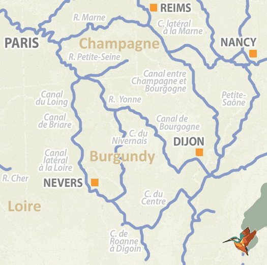
The Champagne route leaves Paris via the Marne; the other options involve taking the Upper Seine to the confluence town at Sainte-Mammes where you can opt for the Canal du Loing, you can join the Yonne at Montereau and then follow the Burgundy canal or keep going even further until you connect with the Nivernais canal just south of the enchanting town of Auxerre.
▶ Detailed canal and river information – Central France
Upper Seine (Haute Seine and Petite Seine)
The lower Seine consists of the 348km stretch from Le Havre to Paris, while the upper Seine takes you from Paris to Montereau (98km) and the Petite Seine from Montereau to Marcilly and beyond (the source is in the Cote d’Or about 30km from Dijon).
At Montereau the Seine is joined by the canalised River Yonne which has upstream connections to the Burgundy and Nivernais canals, and a little further downstream at Saint-Mammes, the river links to the Canal de Loing which, with the Canal de Briare and the Canal Lateral a la Loire, forms the Bourbonnais route to the south.
There is a high volume of heavy commercial traffic, much of it consisting of one thousand tonne barges carrying grain from Paris to the busy terminal at Nogent, but this in no way detracts from the delights of the upper Seine, which is largely unspoilt with ravishingly pretty scenery.
▶ Detailed canal and river information – Upper Seine
The River Marne and Marne Latéral
In spite of a tiny (500m) section of canal around Meaux that was built in 1235 and is said to be the oldest in France, the Marne was a free-flowing navigable river until 1867 when a canalisation project thirty years in the making reached as far as Epernay. The Canal Lateral a la Marne begins at Dizy, 178km from the confluence with the Seine at Charenton in Paris. The canal junction is 5km downstream of Epernay and the stretch on to Epernay is treated as a short branch of the river. The Lateral a la Marne ends 65km later at Vitry-le-Francois and the junction with the Champagne to Burgundy canal.
The river itself follows a winding course and some of its more excessive loops have been shortened by means of smaller canals including the Meaux a Chalifert (12km), the Chelles (9km) and the St Maur (1.2kmcomplete with a six hundred metre tunnel). There are two islands after Bray-sur-Marne, the Il d’Amour, and the Il des Loups, where the left bank channel is reserved for downstream vessels and the right bank for those heading upstream.
As you cruise along through the fabled vineyards of Champagne, it can be fun to spot the concrete marker posts at the end of individual rows labelled with famous names such as Moet, Mercer, and Mumm. It is even more fun to stop off and taste the wines themselves.
▶ Detailed canal and river information – Marne
Canal entre Champagne et Bourgogne
This delightfully rural canal is only used by approximately a hundred boats a year so the chances are you’ll have long stretches to yourself and can meander along at your own pace. Originally called the Canal de la Marne a la Saone, it was constructed as part of the Freycinet programme to build 1400 km of new waterways in the late 1870s, but budgetary constraints meant that the canal was not completed until 1907. These days it forms the second part of the Marne route south, and its 224km length begins in Vitry le Francois and ends at Heuilly-sur-Saone.
It is the longest route from Paris to Lyon, but this is compensated for by the fact that there are fewer locks than the Burgundian or Bourbonnais options. It can also provide a quiet and convenient route from Northern France to the Saone, travelling through remote, countryfied areas as it crosses the Langres plateau and descends of the Vingeanne valley. There is a small amount of commercial traffic whose presence helps to maintain the depth, but one note of caution: the downside of all the peace and tranquillity is that it is poorly provided with facilities especially along the first 70k, and you may have problems topping up with fuel so make sure you start with a full tank.
▶ Detailed canal and river information – Canal entre Champagne et Bourgogne
River Yonne
The canalised section of the River Yonne runs for 108km from the stunning old city of Auxerre where the river joins the Canal du Nivernais, to the junction with the Seine at Montereau. It was a free-flowing river until the 1830s when engineers Poiree and then Thenard perfected a design for needle weirs, a development which led the government to approve the canalisation of many French rivers. The first lock and weir was built on the Yonne in 1840, but the work was not completed until the 1860s, then enlarged to Freycinet specifications in the late 19th century and to their current dimensions following the Second World War.
The Yonne locks are distinguished by the fact that they have sloping sides which can be challenging particularly when you are descending and cannot reach the bollard to tie your ropes on. Having a boat hook to hand is a good idea. Leisure boats will find it a great link to the Burgundy and Nivernais canals and it is delightful to cruise on, but it is an important route for commercial traffic as well, the more so closer to Paris.
▶ Detailed canal and river information – River Yonne
Canal de Bourgogne
The canal is the shortest and most heavily locked route across Central France. It starts at Laroche-Migennes in the north and after 242km finishes at the St Jean de Losne junction with the Saone in the south. Building the northerly section began in 1774, construction from the south reached Dijon by 1808 and the connecting link was completed in 1832. Since then there have been improvements under the Freycinet scheme, but the tunnel at Pouilly en Auxois remains a bottleneck. Before you pass through its 3.33km length, a lock keeper will check that you have sufficient life jackets, lights, and a working horn, and if you ask him make even provide you with short logs to lash on to your bows and stern to stop you bumping into the sides.
At 378m, the summit at Pouilly is the highest in the land and there is a lovely sense of being out in the wilds. In contrast to this you will encounter a wide range of fascinating tourist sites either on or close to the canal – our favourites include the chateau at Ancy-le-Franc and the Ducal Palace in Dijon. Because it is so rich in history and gastronomy, the route is extremely popular with hotel barges, who have priority at locks and other facilities.
▶ Detailed canal and river information – Canal de Bourgogne
Canal du Nivernais
The quintessential French canal, the Nivernais creates a 174km passage between the Yonne and the Loire, allowing a connection with the Burgundy canal at Laroche Migennes on the Yonne in the north and the Canal Lateral a la Loire via Decize and then Saint-Leger-des-Vignes in the south, creating at least three delightful cruising circuits around central France – enough to keep an enthusiastic plaisancier going for many years.
Begun in 1784, the Nivernais was originally built in order to ship logs from the remote Morvan heathland down to Paris, where they were used for construction and fuel, and in return coal was shipped out to the region. However, locks in the middle section between Cercy and Sardy were never upgraded to Freycinet dimensions so that the waterway is unusable for standard freight vessels. While this led to its decline during the 19th century when the railroads gained a stranglehold over the transport of goods and people, it can be seen as a positive thing as the ineffable charm of the canal has been protected from the ravages of industrialisation. There are 112 locks, three tunnels and more art installations, pottery exhibitions and small galleries along the route then you can shake a stick at. In a sense, with its irresistibly pretty countryside and atmospheric medieval villages, it is a work of art in Its own right and arguably more picturesque than any canal on the network. The two historic centres at Clamecy and Auxerre are worth exploring too.
▶ Detailed canal and river information – Canal du Nivernais
Canal du Loing
Travelling in a southerly direction, the Canal du Loing is the first of three waterways which combine together to form the Bourbonnais route north to south across central France. The Loing connects the Yonne at Saint-Mammes with the Canal de Briare north of Montargis and is 49km in length. Plans drawn up by the Duc d’Orleans to improve navigation on the River Loing were given royal assent in 1720 and work was completed a mere three years later. The waterway was upgraded to Freycinet dimensions at the end of the 19th century.
The Loing is high on the list of plaisanciers’ favourites, as it passes through entrancing landscapes and there are many attractive villages to explore along the way. Be sure to stop at Moret-sur-Loing, a historic town so pretty it was painted by a number of celebrated Impressionist artists, including Sisley and Pisarro. The highlight of the waterway is the aqueduct at Briare which carries the canal across the River Loire. Elegantly designed in the classical style, until 2003 when the Magdeburg Water Bridge was opened, it was the longest navigable aqueduct in the world. It has fifteen stone arches supporting a metal trough that is 662m long.
▶ Detailed canal and river information – Canal du Loing
Canal de Briare
The 57km long canal forms the central section of the Bourbonnais route from the north to the south of central France, connecting the Canal du Loing with the Canal Lateral a la Loire. It was a project initiated by one of France’s most popular Kings, Henry 1V, who saw its potential as a lifeline for Paris, bringing in fuel and grain from the countryside to the capital. Work was briefly interrupted by the king’s assassination in 1610 but resumed under new contractors in 1638 and was finished in 1642. There were some upgrades in the 1830s but the waterway had to be almost completely rebuilt to meet the standards of the Freycinet gauge, and an atmospheric relic of its earlier infrastructure can be seen in the abandoned locks at Rogny.
The town of Briare itself is home to one of the largest and most popular ports de plaisance on the entire network.
▶ Detailed canal and river information – Canal de Briare
Canal Latèral à la Loire
The Canal Lateral a la Loire is 196km long and has as many branches as a tree. There are six in all: the Decize, the Dompiere, the Nevers, the Givry-Fourchambault, the St Thibault and the Chatillon. These vary in importance. The Decize branch crosses a dredged channel in the Loire to lead on to the Canal du Nivernais; the Nevers leads to the town of that name, which is the prefecture of the Nievre department; the Dompiere leads to the small town of Dompierre-sur-Besbres which has a hire base; the Givry-Fourchambault and the Saint-Thibault both lead down to the Loire by different means; the Chatillon leads down to the St Mantelots which used to link to the principal crossing of the Loire River, before the Briare aqueduct was built.
The Briare pont de canal was the elegant solution to the extremely troublesome problem of how to maintain a safe crossing over the river Loire during its frequent periods in flood. It was constructed by the Eiffel company who built the iconic tower for which Paris is most famous, and from its inauguration in 1896 until as recently as 2003 it was the longest navigable aqueduct in the world.
▶ Detailed canal and river information – Canal Latèral à la Loire
Canal du Centre
The canal was begun at the same time as the Canal de Bourgogne but completed in 1793, forty years before its rival. One of the earliest waterways to cross the watershed of central France, in its day it was regarded as an engineering marvel and its 112km length runs from Chalons-sur-Saone in the south via the mining town of Montceau-les-Mines until it reaches Digoin, where it connects with the Canal Lateral a la Loire, making it the first waterway to connect the Saone and Loire Rivers. The locks were upgraded in the 1830s and then again in the 1890s so they were compatible with Freycinet dimensions.
With coal mining out of fashion, there is very little freight along the canal, which follows a winding course through wooded countryside that is extremely beautiful in places, particularly in the north western section. The exquisite Chateau de Digoin is privately owned but is occasionally open to members of the public and if your luck is in, don’t miss the chance to visit. It has a beautifully restored 18th century theatre where the legendary French actor Sarah Bernhardt is said to have performed.
▶ Detailed canal and river information – Canal du Centre
French waterway regions – North | North-East | North-Central | West | Centre | South-East | South | South-West
British-Irish waterway regions – Northern | East Midlands | West Midlands | Welsh | Southern | Scottish | Irish