
Rivers and Canals of Nord / Pas de Calais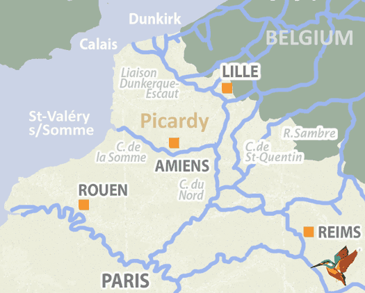
Every year thousands of boat owners begin their voyages through France via Dunkerque (Dunkirk) which is considered to be a prime choice of entry port. There are some fascinating local canals to explore if you are not in a hurry before you take the high-capacity (grand gabarit) waterway towards Lille and Douai and then onwards. Historically a region associated with heavy industry and coal mining, it remains one of the friendliest and most welcoming in the whole country. The landscape is varied and the moorings offer a range of quality and facilities, but recently there has been a good deal of local investment to improve the appearance of waterfronts, particularly in Dunkerque and Lille, and more is planned.
The most spectacular route into France is via the Somme estuary, although bear in mind that there are tidal constraints when accessing the port of Saint-Valéry. As a waterway the Canal de la Somme is rich in history having poignant associations with the First World War – if you moor at Peronne don’t miss the wonderful Museum of the Great War based in the local chateau. Amiens was at the centre of the 1918 offensive which ended the war and is well worth a visit, or a detour for those coming south on the Canal du Nord.
▶ Detailed canal and river information – Northern France
Dunkerque
The reason that Dunkerque is one of the most popular ports of entry into France is that it is the gateway to three different canals and used to provide boaters with a significant choice of onward routes. The Canal de Furnes takes you east along the coast towards Belgium and is the most useful, as the onward links from the two other canals, the Canal de Bergues, and the Canal de Bourbourg, have been closed, or in the latter case superseded by the Liaison Dunkerque Escaut, but they still provide interesting short cruises. The port of Dunkerque itself has a range of facilities including a technical and boatyard section and an excellent marina, the Yacht Club de la Mer du Nord but the route out of it is a little tortuous – call the harbourmaster on VHF73 to advise him of your passage plans.
Navigationally, the area has a rich history as the three canals owe their origins to historic waterways. The Canal de Furnes was part of an ancient drainage system which was canalised by the Spanish in 1669 when they were rulers of the Lowlands. The course of the Canal de Bergues dates right back to the ninth century and leads to the eponymous Bergues, an attractive town which was fortified by the legendary military engineer Vauban and featured in the cult film Bienvenue chez les Ch’tis. The Canal de Bourbourg dates from 1769 and was formerly a key link between the port and the surrounding area, but the construction in 1960 of the Liaison Dunkerque Escaut, built to transport high capacity traffic, significantly reduced its importance.
▶ Detailed canal and river information – Dunkirk Canals
Calais
As the closest point to England, Calais is another popular gateway to the waterways of France. The marina is entered via a sea lock and you need to call VHF17 to arrange access, which is available for ninety minutes either side of high tide. The Canal de Calais is 29.5km long and follows a route from the port to the junction of the River Aa at Le West and is regularly used by commercial traffic of up to six hundred tonnes for approximately two thirds of its length, although the Freycinet tidal lock at the port limits its usage by larger vessels.
The canal was completed in 1758 and has three short branches off it, to Guines, Ardres and Audruicq, but they suffer from disuse and a shallow draft of only 1m, so are not really viable as navigations. Look out for the Pont sans Pareil, a four branched bridge that crosses the junction of four different canals – it was regarded as an engineering masterpiece back in the day…
▶ Detailed canal and river information – Calais Canals
Liaison Dunkerque Escaut
Known affectionately as La Liaison, this large-scale waterway was constructed during the late 1960s to carry freight traffic from the busy international port at Dunkerque to the industrial centres at Denain and Valenciennes. 143km in length, it has incorporated or linked up a series of older canals and its most significant branch is the Canal de Deule which extends to Lille and connects with the River Lys. The Canal de Lens is another important branch built to serve the coal-mining area around the town of Lens, but as the use of fossil fuels has declined, many of the industrial quays are no longer needed, levels of pollution have consequently fallen and the waterway is starting to become a more attractive prospect for the cruising sector.
This is exemplified in the last stretch of La Liaison, along what used to be the Canal de la Sensee. Its 3.7km length ends at the River Escaut but on its way passes through the Bassin Rond, a canal basin wide enough for leisure use – it is not uncommon to see dinghies in full sail here.
▶ Detailed canal and river information – Dunkirk-Escaut
Canal de la Deûle
Once known as the Antenne de Beauvin a la Lys, the name that locals use – La Deule – has been adopted by everyone including the VNF. The canal is now 35km long and the one that it replaced was originally designed by engineering genius Vauban and opened in 1693. It was rebuilt during the 19th century and extended through Lille where bargees had previously had to trans ship from the Haute Deule to the Basse Deule. There is an increasing level of commercial traffic heading for the large container port south of the city and boaters may encounter a significant amount of water sport activity around Canteleu, so you are advised to proceed with caution. In the near future work will begin downstream of Lille to upgrade the canal so it meets European Class Vb dimensions enabling it to carry ships up to 185m long and 12 m wide.
In fact there is significant renovation in the area: there are also plans afoot to restore navigability to Vauban’s old branch through the centre of the city, and in 2011 the Canal de Roubaix, which links to the Deule at Marquette south of Lille, was opened to navigation after fifteen years of restoration work, placing the Deule at the heart of a number of interesting cruising loops.
▶ Detailed canal and river information – Canal de la Deule
River Lys
The canalised section of the River Lys runs for 65km from its junction with the Liaison Dunkerque Escaud to its confluence with the River Scheldt at Ghent in Belgium. The river has been used for navigation since the Middle Ages but was prone to terrible floods affecting the surrounding lowlands and this led to its canalisation from around 1670, when eventually six locks and weirs were built to help manage the problem. The Lys was used to carry grain and linen from Antwerp to Ghent and was upgraded to Freycinet dimensions in the late nineteenth century. For 24 km south of Armentieres it forms part of the Franco-Belgian border and this shared section has been improved so that it can provide a high capacity link to the Canal de Deule.
Boaters will encounter significant commercial traffic downstream of Armentieres, but upstream as far as Aire sur la Lys it is possible to enjoy a pleasant cruise through rural Flanders, stopping to enjoy many delightful villages as you go. There is a good port de plaisance at Pres Duhem and attractive moorings along the way.
▶ Detailed canal and river information – River Lys
River Escaut
Linked to the Canal St Quentin at Cambrai and crossing the Belgian border at Mortagne, the River Escaut is an important part of the northern French waterways jigsaw. It was originally developed in Belgium and then extended towards Valenciennes, and the route onwards to Cambrai was completed in 1788. The river connects a number of key industrial towns; Douai and Valenciennes on the French side of the border, and Antwerp and Ghent in Belgium, where it is known as the Scheldt. Fifty-nine kilometres of the Escaut have been canalised in order to enable the passage of heavy freight from the Paris region as far as the Netherlands and from its junction with the Liaison Dunkerque Escaut it is capable of carrying 1350 tonne barges.
Although commercial traffic remains a big feature of the waterway, in a post industrial age where many factories along its banks have been demolished or abandoned, sections of the Escaut are surprisingly rural and make a pleasant cruising prospect.
▶ Detailed canal and river information – River Escaut
Seine Nord Europe Canal
The effects of global warming are putting increasing pressure on governments to minimise their CO2 emissions and this is one of the drivers behind the multinational project to link the Seine basin in France with the Rhine basin in Germany, so that it will be possible to transfer significant amounts of freight from the congested roads of northern France to the waterways. Predicted to be completed in 2028, the French part of this 106km project will replace the Canal du Nord, part of the Canal Lateral a l’Oise and the River Oise itself, starting in Aubencheul-au-Bac and ending at Compiegne on the Oise.
At the moment this route is only accessible to barges up to 650 tonnes, but capacity will be increased to an enormous 4400 tonnes. The scheme embraces the railway network too, as four new hubs will be built along the route to make the transfer of goods between systems as efficient as possible. Although this is primarily a commercial project, it is thought that boats will be allowed to use the canal and five moorings for passenger vessels will be built. The technical specification for the Seine Nord Europe Canal is impressive: the largest lock, at Moislains, will be 30m deep and there are plans for an aqueduct 24m high across the river Somme.
▶ Detailed canal and river information – Seine Nord Europe
Canal de Saint-Quentin
For a hundred and fifty years the Canal de Saint-Quentin was the only link to the industrial north of France. Construction work on parts of the route began in 1724 and the concession passed through different hands and was bedevilled by financial problems until Napoleon intervened – the project was swiftly completed and he opened the canal himself in 1810. To this day it is part of the national priority network, which is an indication of its importance.
The canal is 92.5km long and connects the canalised River Escaut at Cambrai to the Canal Lateral a l’Oise at Chauny. The northern section of the valley is an agreeable place to cruise and one of the navigational highlights is the Grand Souterrain tunnel. At 5.67k this is the longest tunnel in use on the French waterways and all boats passing through must be pulled by electric chain tugs. Departures northbound from Riqueval are at 07.30 and 15.00, and southbound from Vendhuile at 09.30 and 17.00. Boats are roped together in order of size, with the largest first and cruises are permitted to tie on behind the smallest. There is a charge for this service and users will be invoiced afterwards by the VNF.
▶ Detailed canal and river information – Canal de Saint-Quentin
River Sambre and Canal de la Sambre à l’Oise
Engineers have had ambitions to link the Rivers Seine and Meuse from the late 17th century onwards, but works were not started on the project until 1834-9, when the Sambre was canalised and the canal extension was dug, creating a route 121km long that consists of navigable river from the Belgium border to Landrecies, where the Canal de la Sambre a l’Oise eventually connects with the Canal de Saint-Quentin.
The waterway has become extremely popular with cruises entering France from Belgium and the Netherlands and after a fifteen year closure for renovations which included the reconstruction of two aqueducts at Vadencourt and Macquencourt, it was fully re-opened in July 2021. From Charleroi, the Sambre winds its way through attractive countryside that has now been de-industrialised, for example Hautmont has an excellent port de plaisance on the site of an old steel works – part of the significant investment in tourism within the region.
▶ Detailed canal and river information – Sambre
Canal de la Somme
Between 1770 and 1843 work was carried which effectively canalised the River Somme in order to create a link between Saint Quentin and the sea. The Somme was thought to be a faster and more reliable river than the Seine, particularly when it came to transporting goods from England. The plan was originally conceived in 1729 and full authorisation was given by King Louis the 16th in 1785, but work was soon interrupted by the Revolution. Napoleon subsequently upgraded the specification for the project to include a ship canal between St Valere and Abbeville. The canal was finally opened in 1839 and its locks were later enlarged as part of the Freycinet programme.
Enter Saint Valery from the Somme estuary and 156 km later you will arrive at Saint-Simon, which links to the Saint Quentin Canal. Commercial traffic has reduced to a minimum and you will find yourself passing through marshy valleys dotted with peat bogs and lakes, on one of the prettiest waterways in northern France.
▶ Detailed canal and river information – Somme
French waterway regions – North | North-East | North-Central | West | Centre | South-East | South | South-West
British-Irish waterway regions – Northern | East Midlands | West Midlands | Welsh | Southern | Scottish | Irish