
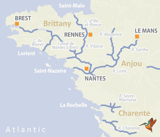
Rivers and Canals of Brittany, Anjou and Charente
The waterways of Western France tend to be small and perfectly formed and are therefore only accessible by boat if the water draft is one metre or less. While this may be frustrating for the owners of larger craft, it means the little guys who can access the delightful and characterful canals of Brittany, the Loire and northern Aquitaine won’t have to dodge large freight vessels and will have the place more or less to themselves.
Some of the original canals are no longer fully accessible – sections of Napoleon’s grand project to construct a 340km canal complete with 236 locks from Nantes to Brest is one of the casualties of freight moving from the water to rail – but there are plenty of remaining options to explore and each of the western regions has its own distinct character. Brittany had a strong cultural identity and has retained much of its own patois; the Loire is rich in history – think waterside chateaux with fairy tale turrets – and it has a deserved reputation for viticulture (Sancerre, Saumur, Muscadet, Rose d ’Anjou to name but a few); Aquitaine offers the coastal delights of La Rochelle and islands of Oleron and Il de Re, not to mention the delights of Cognac and Pineau des Charentes. As a region, western France is sometimes overlooked by waterways enthusiasts, but this means that the experience is all the richer for those who take the trouble to investigate it.
▶ Detailed canal and river information – Western France
River Charente and River Boutonne
The Charente runs from Angouleme to the sea over a distance of 164 km and was described by the French King Francois 1 as, “…la plus belle riviere du royaume.” This beautiful waterways certainly deserves the accolade and the stunning scenery makes up for the fact that the river is cut off from the rest of the French network – don’t let its isolation discourage you from exploring it and if you don’t want to take your own boat there are a number of hire bases to choose from. Plans to canalise the Charente were begun in 1772 but then stalled by the French Revolution. The works, which included the construction of twenty-one locks, resumed when the dust settled and were finished in 1835. The departments of Charente and Charente Maritimes took over responsibility for the waterway in 1952 and 1963 respectively and have committed to maintaining the navigability of the route.
The River Boutonne is an attractive tributary of the Charente and from the confluence to the town of Saint-Jean-d’Angely provides 29 km of pleasant cruising, with four locks to pass through.
▶ Detailed canal and river information – River Charente
River Loire
At 880km the Loire is the longest river in France but its flow veers from drought levels of only 25cm to full-on floods depending on the season, which means its upper and middle courses are only navigable at Decize, where it connects the Canal Lateral a la Loire with the Canal du Nivernais.
The Loire becomes fully navigable downstream at the confluence with the River Maine at Bouchemaine, thus linking the Maine and its tributaries the Mayenne, the Oudon and the Sarthe to the Canal de Nantes a Brest, creating a delightful cruising route that is 84 km long. The inland stretch of river ends at Nantes, which in 1700 was the busiest inland port in France. Indeed, flat bottom Gabares continued to carry freight, including coal from Saint-Etienne to Orleans, until the mid-1800s, when the advent of the railways put these traditional craft out of business.
Between Nantes and Saint-Nazaire the Loire and its estuary are categorised as a maritime navigation.
▶ Detailed canal and river information – River Loire
Canal de Nantes à Brest
In its heyday the Canal de Nantes a Brest was the most ambitious waterways project in France, running for 340 km and containing 236 locks. Its origins were military: to connect the strategically significant ports of Nantes and Brest by means of an inland route should the British decide to blockade access by sea. The canal was closed as a through route in 1920, partly to facilitate the construction of the Guerledan dam.
Now under regional control, and recognizing the significant contribution that waterways tourism makes to the local economy, there has been considerable investment and extensive dredging, with the result that the isolated western section has been extended and now runs for 81km from Goariva to Port Launay, the 26km middle section from Guerledan to Melloinec has now opened and the main eastern section from Nantes to Guerledan consists of 225 km of excellent cruising complete with 116 locks (further restoration is needed to make the last 21 km to Guerledan fully navigable).
▶ Detailed canal and river information – Canal de Nantes à Brest
French waterway regions – North | North-East | North-Central | West | Centre | South-East | South | South-West
British-Irish waterway regions – Northern | East Midlands | West Midlands | Welsh | Southern | Scottish | Irish