
Rivers and Canals of the Saône-Rhône Valley
The fluvial equivalent of a motorway extending from Central France to the Mediterranean, the Soane and Rhone rivers are regularly used by huge canal barges, push tows and more than twenty passenger cruise ships, but at the same time they are a vital artery for pleasure boats as well and both waterways are large enough to accommodate all comers.
A good deal of the Saone meanders through ludicrously pretty countryside, giving the impression that you are in the heart of rural France, and there are a couple of delightfully bucolic detours you can make along the River Doubs at Verdun-sur-Doubs and the River Seille south of Tournon, but the character of this river corridor changes at Chalons-sur-Saone which is the starting point for many of the passenger ships and the larger freight vessels.
On these mighty rivers, locks tend to be very rare but the opportunity for spontaneous moorings is also less than elsewhere, particularly on the Rhone where it is not advised at all. To compensate for this there are a number of excellent port de plaisances, notably at Roches de Condrieu, Valence l’Eperviere and last but not least, Avignon. Once you reach the Rhone delta you can continue out to sea via Port-Saint-Louis or chose to cross from sea to shining sea by means of the Canal du Midi and the Canal Lateral a la Garonne, now collectively known as the Canal Entre Deux Mers.
▶ Detailed canal and river information – South-East France
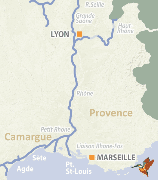
River Saône (Grande Saône)
The Grande Saone is the stretch of river that runs between the Petite Saone to the north and the Rhone to the south, flowing from the major waterways hub of St-Jean-de-Losne down to Lyon. It is significant because all the canals of northern, central, and north-east France funnel into it, thus providing a vital high-capacity link in the route down to the Mediterranean. The main junctions along the way include the Canal de Rhone au Rhin at Saint-Symphorien, the Canal du Bourgogne at Saint-Jean-de-Losne and the Canal du Centre at Chalons-sur-Saone.
Now capable of carrying three thousand tonne barges and cruise ships up to 110m in length, the canalisation of the river was first envisaged by the Roman emperor Vetus, indicating that it has always been viewed as a major arterial route. In the middle ages local landowners used to put chains across from bank to bank in order to force passing boats to stop so that they could charge tolls, but now passage is unimpeded – and indeed, facilitated by five grand gabarit locks.
▶ Detailed canal and river information – River Saône
River Seille
Exploring the Seille by boat is like sailing into a landscape painted by Corot – it is one of the most attractive rivers in the French network, entered via a junction with the Saone at La Truchere just south of Tournus and winding prettily for 39 km as far as Louhans. It was canalised in the 19th century to provide access from this busy market town to the major waterway of the Saone and includes four locks, making your passage easy. There are two hire bases at Louhans and Brangery and some excellent pontoon moorings, as well as numerous opportunities in idyllic spots on shady banks, even tied up to a tree. Don’t miss it – small and perfectly formed, it’s definitely worth the detour.
▶ Detailed canal and river information – River Seille
River Rhône
The Rhone is a mighty river which in former times struck fear into the heart of inland navigators, but between 1931 and 1980 a massive programme of works was carried out in order to tame the tempestuous flow. Eleven diversionary canals now combine with sections of deep river to provide a safe route for boats and the twelve impressive hydro-electric power stations with their accompanying locks which were constructed between 1964-1980 are capable of providing sixteen per cent of France’s electricity.
Starting at the confluence with the Saone in Lyon, the river runs for 310km to Port Saint-Louis, which offers access to the Mediterranean. The Saone provides links with canals to the north, north east and centre of France, while the southern stretches of the Rhone have been significantly altered by the canalisation work so that it is no longer possible to connect with the Canal du Rhone a Sete at Beaucaire. Instead, the Petit Rhone has been vastly improved for navigation by means of extensive dredging and there is a pleasant 20km stretch from Fourques to Saint-Gilles, where a short link takes you onto the Rhone a Sete.
The Mistral can still present challenges and navigation on the Rhone can be tricky for leisure boaters for days at a time if it is blowing hard, but there are attractive towns along the route, so this is not necessarily a hardship – find a safe harbour and go exploring.
▶ Detailed canal and river information – River Rhône
Petit Rhône
A few kilometres upstream from Arles, the Petit Rhone branches off from the main river at Fourques. Originally one of many narrow channels in the Rhone delta, when construction of the hydro-electric power station at Vallabrueges lowered water levels on the Rhone downstream making the lock at Beaucaire impassable, the Petit Rhone took on a new lease of life as it now formed a critical part of the onward passage to Sete.
Because of this, in 1970 extensive dredging work began to ensure that the tributary had sufficient depth for high capacity barges and the Petit Rhone now offers attractive cruising for 20km to a short cut (and a surprisingly large lock) that takes you on to the Canal du Rhone a Sete. Keep your eyes open – the flora and fauna are both striking and impressive.
▶ Detailed canal and river information – River Petit Rhône
French waterway regions – North | North-East | North-Central | West | Centre | South-East | South | South-West
British-Irish waterway regions – Northern | East Midlands | West Midlands | Welsh | Southern | Scottish | Irish